WEATHER ALERT – RAIN AND FLOODING
SES & BOM has released flood watch for VIC, NSW, QLD & TAS
There Is a large Rain bomb heading toward the East Coast, which is set to bring large amount of rain to already saturated areas of the east coast.
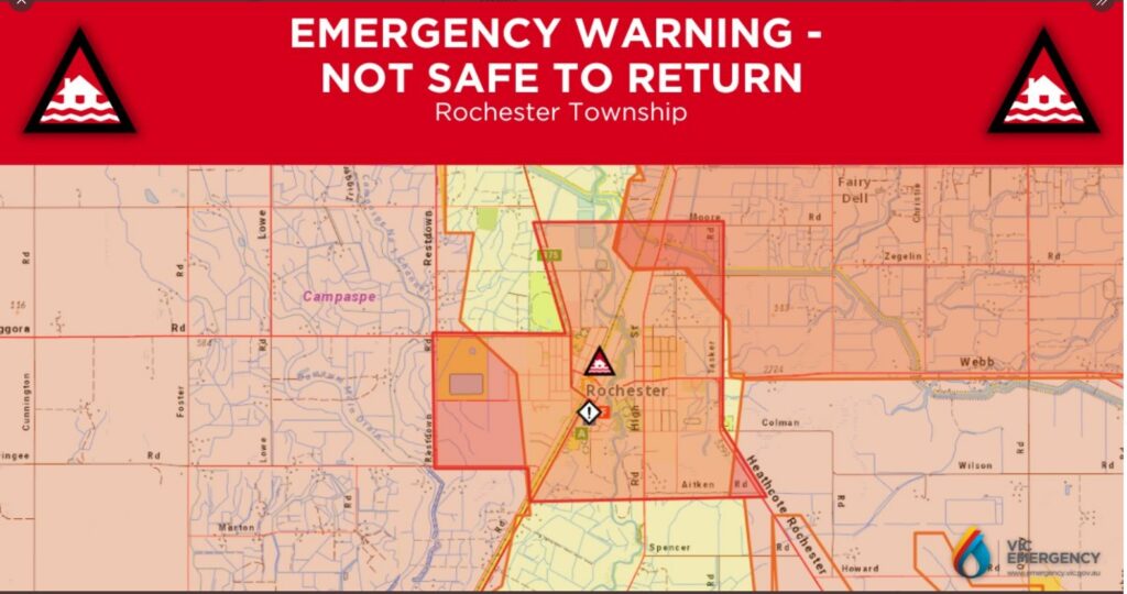
Central Vic – Shepperton, Echuca, Rochester is currently on high alert, please keep listening all local radio and police and please stay safe.
Rochester has been determined not safe to return.
VIC:
• major flooding likely across several northern Victorian catchments
• isolated major flooding likely in the southwest
• widespread minor to moderate flooding expected across northern and parts of western Victoria
• isolated minor flooding possible in parts of Gippsland
Catchments likely to be affected include:
• Macalister River
• Thomson River
• Latrobe River
• South Gippsland Rivers
• Bunyip River and Dandenong Creek
• Yarra River to Coldstream
• Yarra River downstream of Coldstream
• Maribyrnong River
• Werribee River
• Barwon, Leigh and Moorabool Rivers
• Hopkins River
• Otway Coast
• Upper Murray and Mitta Mitta Rivers
• Kiewa River (Kiewa River to Mongans Bridge)
• Ovens and King Rivers
• Broken River
• Broken Creek
• Seven and Castle Creeks
• Goulburn River upstream of Lake Eildon
• Goulburn River Eildon to Seymour
• Goulburn River downstream of Seymour
• Campaspe River
• Wimmera Rive
NSW:
A low-pressure system is forecast to bring heavy rainfall and thunderstorms across New South Wales from Wednesday to Friday, before weakening but will be quickly followed by another rain-bearing system on the weekend.
This rainfall may cause renewed flooding along rivers in parts of New South Wales Northwest, Central West, Southwest Inland catchments from late Wednesday into the weekend, many of which are experiencing ongoing flooding due to previous rainfall in recent months.
• Wollombi Brook and Lower Hunter River
• Hawkesbury and Lower Nepean Rivers
• Upper Coxs River
• Colo River
• Macdonald River
• Upper Macintyre River
• Peel River
• Namoi River
• Castlereagh River
• Macquarie River to Bathurst
• Orange, Molong and Bell River
• Turon and Macquarie Rivers to Burrendong Dam
• Macquarie River d/s Burrendong Dam
• Bogan River
• Lachlan River to Cotton’s Weir
• Belubula River
• Mandagery Creek
• Tumut River
• Upper Murrumbidgee River to Burrinjuck Dam and Cooma Ck
• Murrumbidgee River to Wagga Wagga
• Mirrool Creek
• Queanbeyan and Molonglo Rivers
QLD:
A slow-moving low-pressure system over South Australia is drawing in a deep, tropical airmass over central Queensland.
This is combining with a surface feature across the state to aid severe thunderstorms. Severe thunderstorms are likely to produce damaging winds, large hailstones and heavy rainfall that may lead to flash flooding over the next several hours in parts of the Central Highlands and Coalfields, Central West, Channel Country, Maranoa and Warrego and Northwest districts. Locations which may be affected include Charleville, Longreach, Winton, Isisford, Barcaldine and Blackall.
Severe thunderstorms are likely to produce damaging winds over the next several hours in parts of the Northwest and Maranoa and Warrego districts. Locations which may be affected include Bollon and McKinlay.
• Moderate Flood Warning for the Bulloo River
• Moderate Flood Warning for the Paroo River (QLD)
• Minor Flood Warning for the Condamine and Balonne River Catchments
• Initial Minor Flood Warning for the Barcoo River
• Initial Minor Flood Warning for the Macintyre Brook and Moderate Flood Warning for the Macintyre River.
• Generalised Flood Warning for the Weir River
• Initial Minor Flood Warning for the Moonie River
• Flood Watch for Southern Inland Queensland catchments
• Final Flood Warning for the lower Warrego River (QLD)
TAS:
The following Watches/Warnings are current:
• Final Flood Warning for the Macquarie River
• Final Flood Warning for the Meander River
• Final Flood Warning for the North Esk River
• Final Flood Warning for the South Esk River
Flood Safety Advice:
Remember: If it’s flooded, forget it. For flood emergency assistance contact the SES on 132 500. For life threatening emergencies, call Triple Zero (000) immediately
I am available to answer any questions you may have or provide any guidance you may need so please feel free to contact me.
Whilst BOM are ensuring their predictions are as accurate as possible, the levels of these warnings could and may change at any time. Therefore, if you, your loved ones, or your co-workers are in.
Any of the aforementioned areas (or surrounds, near these rivers) please ensure you monitor these warnings via the below referenced links.
Current Warnings: www.bom.gov.au
VIC Emergency: www.emergency.vic.gov.au/respond
QLD Gov: www.qld.gov.au/alerts
NSW Gov: www.nsw.gov.au
SES VIC: www.ses.vic.gov.au
SES NSW: www.ses.nsw.gov.au
SES QLD: www.qfes.qld.gov.au
SES TAS: www.ses.tas.gov.au
Please be safe.
AJ Grant Building contact details:
1300 254 726
reception@ajgrantgroup.com.au